PHYSICAL HAZARDS AND MOVING WATER
Types of moving water
Rivers, creeks and other inland waterways are natural channels of water which normally flow towards the sea or other bodies of water such as lakes or reservoirs. Tributaries, which are supply channels to rivers, are smaller flows of water created from rainfall, surface run-off and ground water. There are several names given to tributary water flow, including streams, brooks and creeks.
Estuaries are the tidal mouths of rivers (where rivers meet the sea) and these can create complex and dangerous currents. The often-murky water of estuaries is influenced by fresh river water, saline sea water and coastal conditions, including tide and wave motion. These influences contribute to one of the most prominent characteristics of estuaries, which is sedimentation of the waterbed.
At low tide, the thick sediment is exposed. Estuaries can also flow against incoming waves at the estuarial mouth, causing a rip current (or in other words, a current travelling out to sea).
Waterflow and speed
Where rivers (or other waterways) flow in a straight line, the flow is at its greatest in the middle of the river and weakest near the banks (primarily due to friction on the riverbed).
As the water flows close to the riverbanks and riverbed, friction is generated between the water and edges of the river. The effect of the friction is to reduce the speed of water close to the riverbanks and bed.
The fastest flow of water is found furthest from the banks and riverbed in a layer just below the surface of the water.
The speed of the water on the surface layer is slowed due to friction experienced through contact with the air.
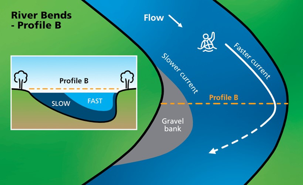
As water flows around bends, the main flow will be on or near the outside of the bend. It is here that the water will usually be at its deepest. Conversely, the slowest and shallowest water can be found on the inside of the bend.
If the water channel gets smaller, the channel gradient increases, or if the volume of water increases, then the speed of the current will increase. This means that water speed can be variable even within the same channel.
Water course relationship with speed of flow
Water speed will vary dependant on the type of water course involved.
The water course will be either:
- Man-made. (i.e. canals)
- Naturally occurring. (i.e. rivers)
Man-made water speed
Variables associated with man-made water speed include:
- Fall of the canal
- Width of canal
- Shape of the canal (vertical wall/trapezoidal walled channels)
- Other canals converging
- Structure of canal (concrete sides or bottom).
Naturally occurring water speed
The speed at which naturally occurring water courses will run is determined by the following variables:
- Friction from composition of the riverbed
- Number of obstructions
- Size of obstructions
- Width and depth of river
- Volume of water
- Fall of the water
Water naturally flows from high to low ground under the influence of gravity. Whilst there are standard natural features that affect normal flow, objects located in the water channel can also create localised effects.
There are two different types of flow created when water moves along on a river or canal
These are:
- Helical flow
- Laminar flow
Helical flow
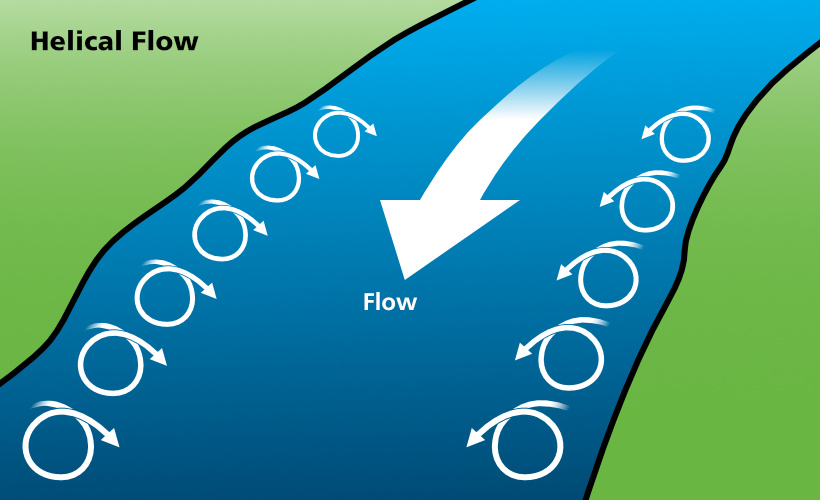
Helical Flow is created along the edges of moving waterways such as rivers, creeks and canals, and is caused by the friction on the edges created as the water flows downstream.
This friction causes water to be slowed and pulled out and down towards the centre of the river/canal. As the current surfaces it moves back towards the area of least resistance, the riverbank where it again cycles down and out.
It is important for visitors and inland waterway management to understand that anyone who falls into this helical flow will be carried into the centre of the river and into the laminar flow.
Figure 2: Helical flow
Laminar flow
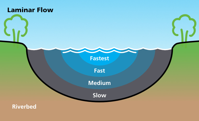
Laminar flow will usually occur in the centre of the river/canal, in the main current.
Effected by friction on the river bottom and sides, the water will flow at different speeds throughout the depth of the current. The lower levels and outer sides will be slowed by the riverbed, whilst the surface will be slowed by friction with the air and potentially wind. As such, the fastest flowing water is just below the surface, at a depth where a person would normally float.
Figure 3: Laminar flow
Current vectors
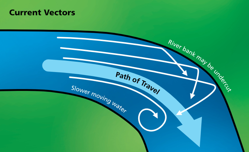
As the water flows in the water course, current vectors will form. This is where the water flows along the river or canal following the easiest and quickest path.
As the river/canal winds its way along, the current will bounce from one side of the river to the other causing vectors to form. A good example of these current vectors is shown by the undercutting of a riverbank on the outside turn in a river.
By understanding these current vectors, a rescuer can anticipate the course that a person will travel along a section of river and position themselves on the correct side of the water course to affect a rescue attempt.
Figure 4: Current vectors
River bends
Rivers tend to meander. When the river bends, inertia forces the main current toward the outside of the bend. As the deeper, faster and more powerful current reaches the outside of the bend, it turns downward and creates a spiralling effect off the bottom of the river that leaves more room for surface water on the outside of the bend. The force of the water tends to erode the outside of the bend where trees and other debris fall into the river. In contrast, the slower, shallower and less powerful current is usually found on the inside of the bend.
Figure 5: River bends (Profile A)
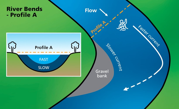
Figure 6: River bends (Profile B)
Water force
The force that water exerts on an object or person is often underestimated. Most people can be easily knocked off their feet, even in shallow and slow-moving water. It is important to understand that the force of the water does not increase at the same rate as its speed. Water especially in the river context, is subject to a variance of properties which can drastically alter the water’s velocity and erosion power.
River loads
As a river/canal flows it has the potential to pick up debris along the way.
This is known as the river load and is broken into three types:
- Top load
- Suspended load
- Bottom load
Top load
The top load is usually made up of floating debris, (objects that are positively buoyant) such as wood, drums, and rubbish.
In flash flooding, the initial wave of water will carry a large volume of debris in the top load and can be dangerous to anyone in the river/canal as the wall of water moves towards them (this is sometimes referred to as the “Golly Wash”).
Suspended load
The suspended load is the portion of a water body’s sediment that is uplifted by the water’s flow and kept suspended by the water’s turbulence. The suspended load generally consists of smaller particles (e.g silt, sand, clay) that makes water clarity very poor.
Bottom load
The bottom load is usually large heavy objects (objects that are negatively buoyant) being pushed along the bottom by the force of the water and assisted by the fall of the water course. The bottom load is extremely dangerous to anyone in the water as they may be crushed or pinned by the objects. Examples can include cars and boulders.
Currents
Currents pose a risk to anybody in the water and even to people in watercraft. Currents vary in strength and can carry people away. Even for a strong swimmer, dealing with a strong current can be tiring and eventually very dangerous.
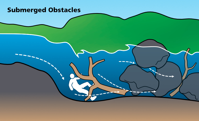
Undertow currents carve out channels in the riverbed creating pockets where water recirculates and can become an entrapment hazard.
Figure 7: Submerged obstacles
Eddies
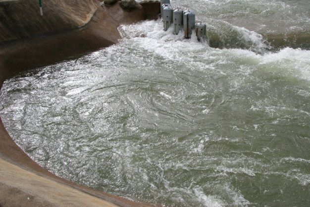
Eddies are caused when water flows around an object (e.g a rock) and then swirls back towards the object, running contrary to the main water current. In most situations, eddies don’t present a high level of danger and, commonly, the calm water behind the obstacle is a safe place to shelter from the current. In rare cases with very powerful currents, eddies may present a holding effect, like a hydraulic (commonly known as a stopper).
The harder and faster the downstream flow, the harder and faster the eddy will flow upstream or recirculate behind the obstacle. A clearly visible line may be seen between the two currents. This is known as the “eddy line”.
This important hydraulic feature can allow a rescuer or victim to escape the main water channel, and make it over to the water’s edge, or even navigate upstream against the current. It can also be used to find a haven mid-stream.
It should also be noted that whilst it is a useful feature to navigate the water course by, on “big flow” rivers these eddies can also contain turbulence and even whirlpools that are a threat to rescuers and victims. As such, rescuers must be constantly monitoring the conditions.
Figure 8: Midstream Eddy and Edge Eddy
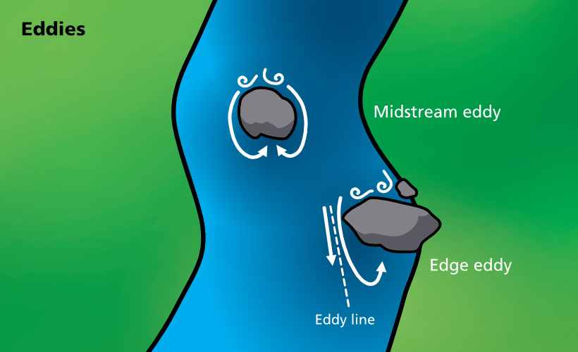
Figure 9: Midstream Eddy
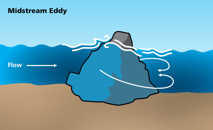
Figure 10: Midstream Eddy
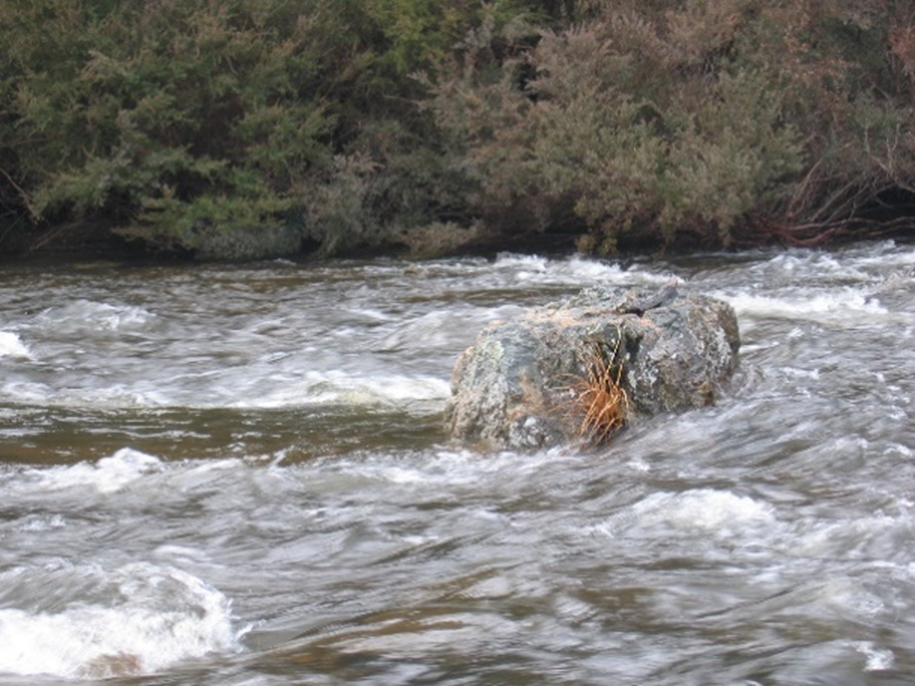
Figure 11: Edge eddy with swirl
Aerated water
Water is agitated as it runs along the water course and can become aerated. This aerated water becomes a hazard as potentially up to 60 per cent of a person’s buoyancy is lost in such water.
Aerated water can cause a person will float very low in the water, causing them to experience the feeling that they are being pulled down, and may lead the individual to panic. It may also cause ingestion of water as the person tries to breath. Even a strong swimmer, wearing a lifejacket or similar floatation device, will float low in the water.
Rocky shallows
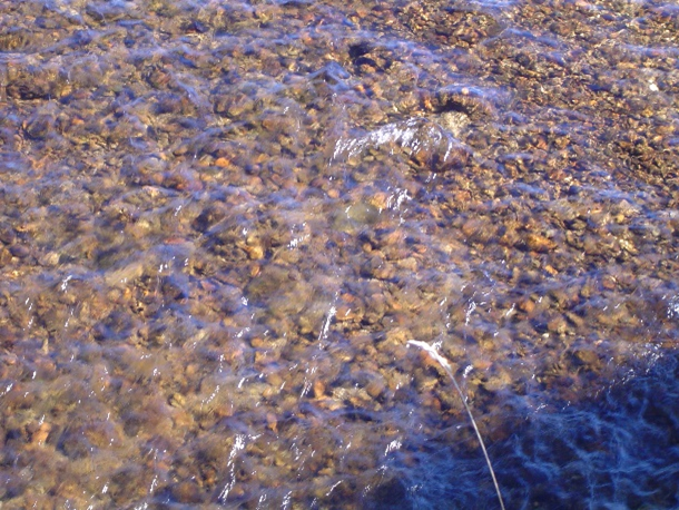
Rocky shallows are typically identified by riffles on the water surface. The rocky bottom may also be visible through the water.
These types of shallows are usually found in natural rivers and streams but can occur in some man-made canals. The submerged river rocks or canal bottom may be found to be slippery under foot, particularly whilst attempting a shallow crossing. Hazards in this context include foot entrapment or slipping and being washed downstream.
Figure 12: Rocky shallows – ripples on the water surface
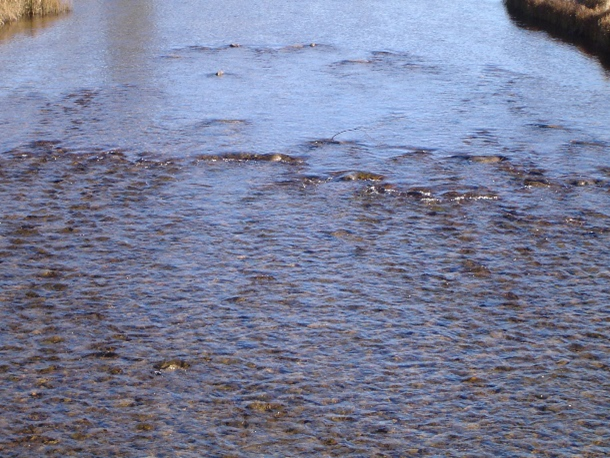
Figure 13: Rocky shallows – the rocky bottom may be visible
Cushion/pillow waves
Cushion or pillow waves form where high volumes of moving water meet a large obstruction (e.g a rock or riverbank), causing the water to ‘pile up’ in front of it. The waves will often push small watercraft away from the obstruction, but the impact and compression of the water can create undercut rocks and banks.
Figure 14: Cushion or pillow waves (water level higher than object)
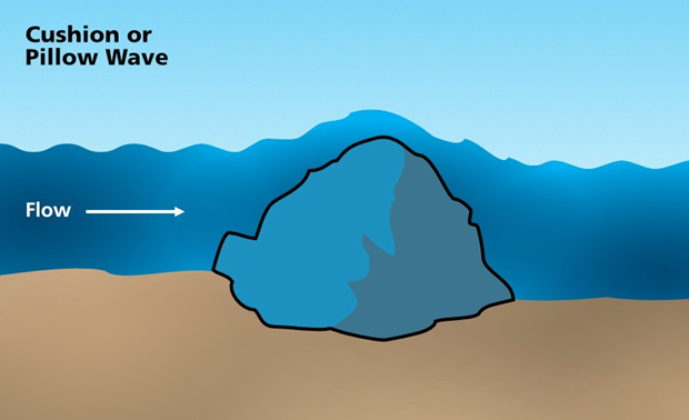
Figure 15: Cushion or pillow waves (water level lower than object)
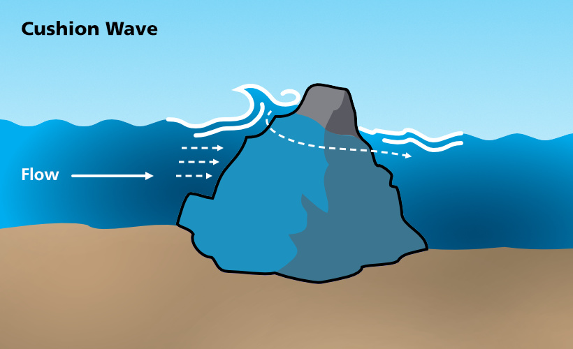
The hydraulic effect created by the obstacle will vary dependent upon depth of water and flow rate.
Holes/standing waves
A “hole” is a surface phenomenon, and as such, can hold surface items on the face of a wave (e.g surface debris, rafts and boats).
A “hole” may be found:
- As water volume increases over the top of a mid-stream obstruction
- At a constriction in the water course
- At a step down in the water course
As the water passes through the constriction or over the obstruction, the water tries to find its own level, causing the wave to break back upstream. The wave breaks continuously in the same position. Variables include:
- Size of the hole
- Flow of the water
Figure 16: Small hole
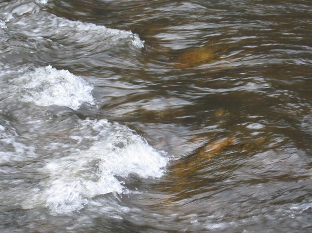
Figure 17: Hole or hydraulic? The designation depends on if the recirculating current is partial or full depth.
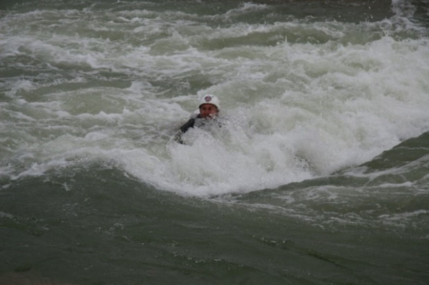
‘Smiling holes’ and ‘Frowning holes’
These “holes” can also be referred to as a ‘smiling’ hole or a ‘frowning’ hole dependent on them forming a ‘V’ pattern in the water course, usually created by a ‘step down’ or ledge.
A ‘smiling’ hole offers a chance to escape its effect by swimming along its length and exiting downstream to either 'river left' or 'river right'.
A ‘frowning’ hole will carry the rescuer/victim to the centre and hold them there. Depending on whether the current is partial or full depth, the feature name may change from a ‘hole’ to a ‘hydraulic’.
A ‘hydraulic’ is like a hole, varying in the fact that it is a full depth recirculating current that may keep an object or person in its hold for an extended period.
Figures 18 to 23 depict different examples of hole/hydraulics with possible escape paths.
Figure 18: Smiling hole/hydraulic
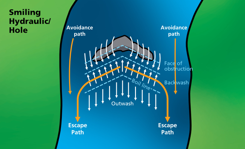
Figure 19: Frowning hole/hydraulic
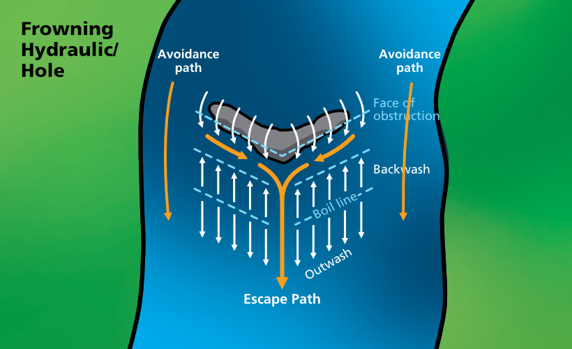
Figure 20: Angled hydraulic
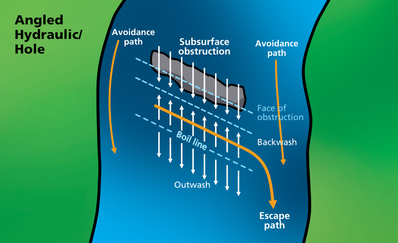
Figure 21: Mid-Stream Hydraulic
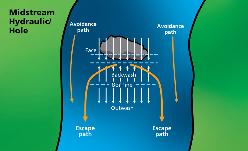
Figure 22: Hole
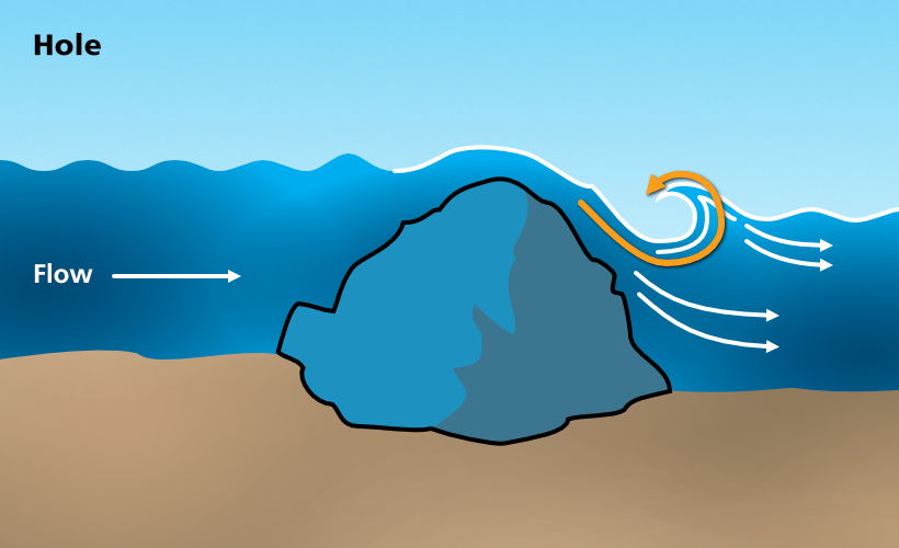
The partial depth recirculating current may hold objects near the surface only.
Figure 23: Hydraulic
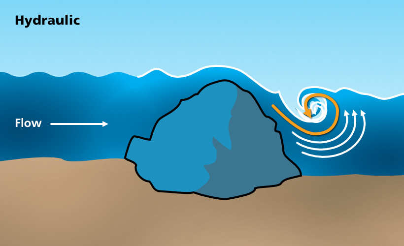
The full depth recirculating current may hold a person indefinitely.
Low head dams or weirs
Low head dams, more commonly called “weirs" are also called ‘drowning machines’ because they are difficult to escape from.
Weirs are man-made, overflow style dams commonly found in rivers and canals to control the water level and flow often to make the waterway deep enough for boats to pass through or to reduce erosion. Weirs partially obstruct the flow of the water, forcing it to either flow over the top of its structure, or through sluice gates, creating hydraulics/stoppers. Stoppers occur when water flows over an obstacle and then forms a rapid and aggressive re-circulating flowing motion back towards the object.
Weir hydraulics/stoppers can be extremely dangerous, due to both their powerful re-circulating motion and the fact that they often have walled, uniform edges, presenting no escape route. The features of weirs that likely indicate a powerful and dangerous hydraulic/stopper are:
- The height of the drop over the weir
- The steepness of the weir face
- Floating debris (stuck in the hydraulic/stopper)
- Walled in edges to the weir
- Flow rate over the weir
Figure 24: Low head dam or weir
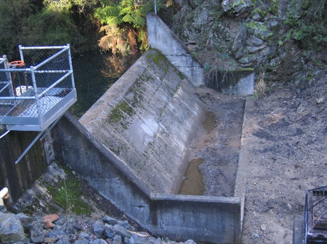
Figure 25: Low head dam or weir
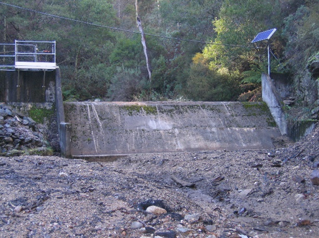
While weirs are usually an engineered solution for controlling the flow rate in man-made water courses, it should be noted that they can also occur in natural water courses as well.
These ‘drowning machines’ are dangerous because:
- The water recirculates vertically upstream as well as running downstream.
- If you are caught in the upstream current you will recirculate, being drawn to the river/canal bottom time and time again
- The weir will normally run full width of the water course, allowing no reprieve.
- The water course will usually have vertical walled or trapezoidal walled channels, making exiting extremely difficult, without assistance.
Swimmers should under no circumstances allow themselves to be washed into a low head dam, normally indicated by an “unknown horizon” as one travels downstream.
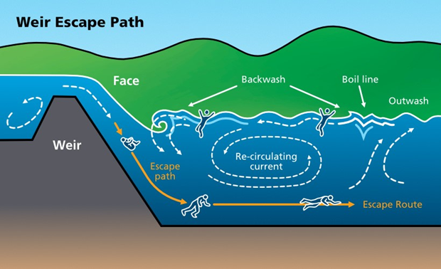
If a swimmer gets caught in a re-circulating current from a weir, the swimmer can tuck into a ball to sink to the bottom and attempt to swim outwards along the river floor.
Figure 26: Low head dam weir currents and escape path
Downstream and upstream v’s
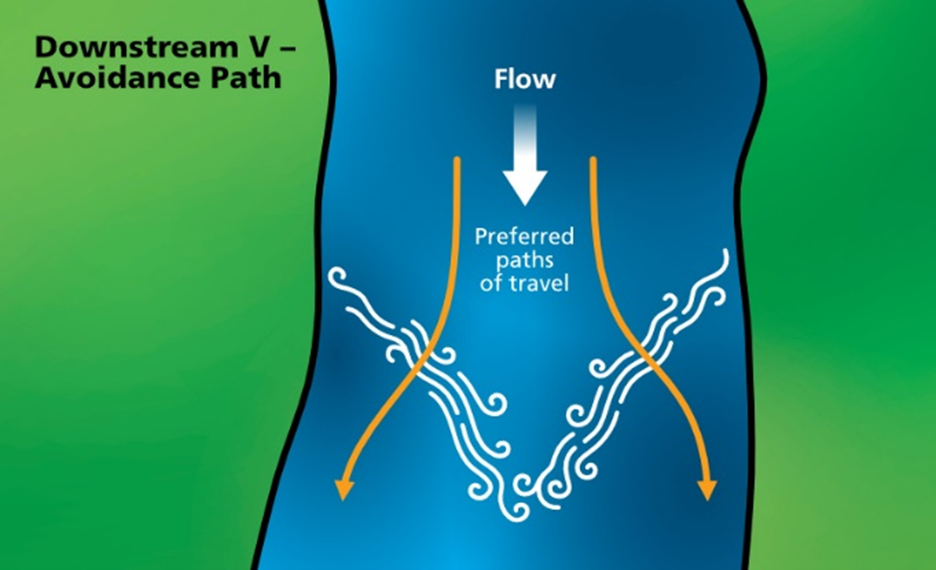
As water flows downstream, over and around various obstacles it can cause a “V” pattern in the water course. These types of features are referred to as either upstream V’s or downstream V’s dependant on what direction they face.
An “upstream V” will cause the water to fan out around an obstacle. A rescuer should ride past on the “green water” to either side of the “V”.
A “downstream V” on the other hand, has the water funnelling into the point of the “V”. The rescuer should ride the “green water” punching through the white-water.
Figure 27: Preferred Paths of Travel – Upstream V
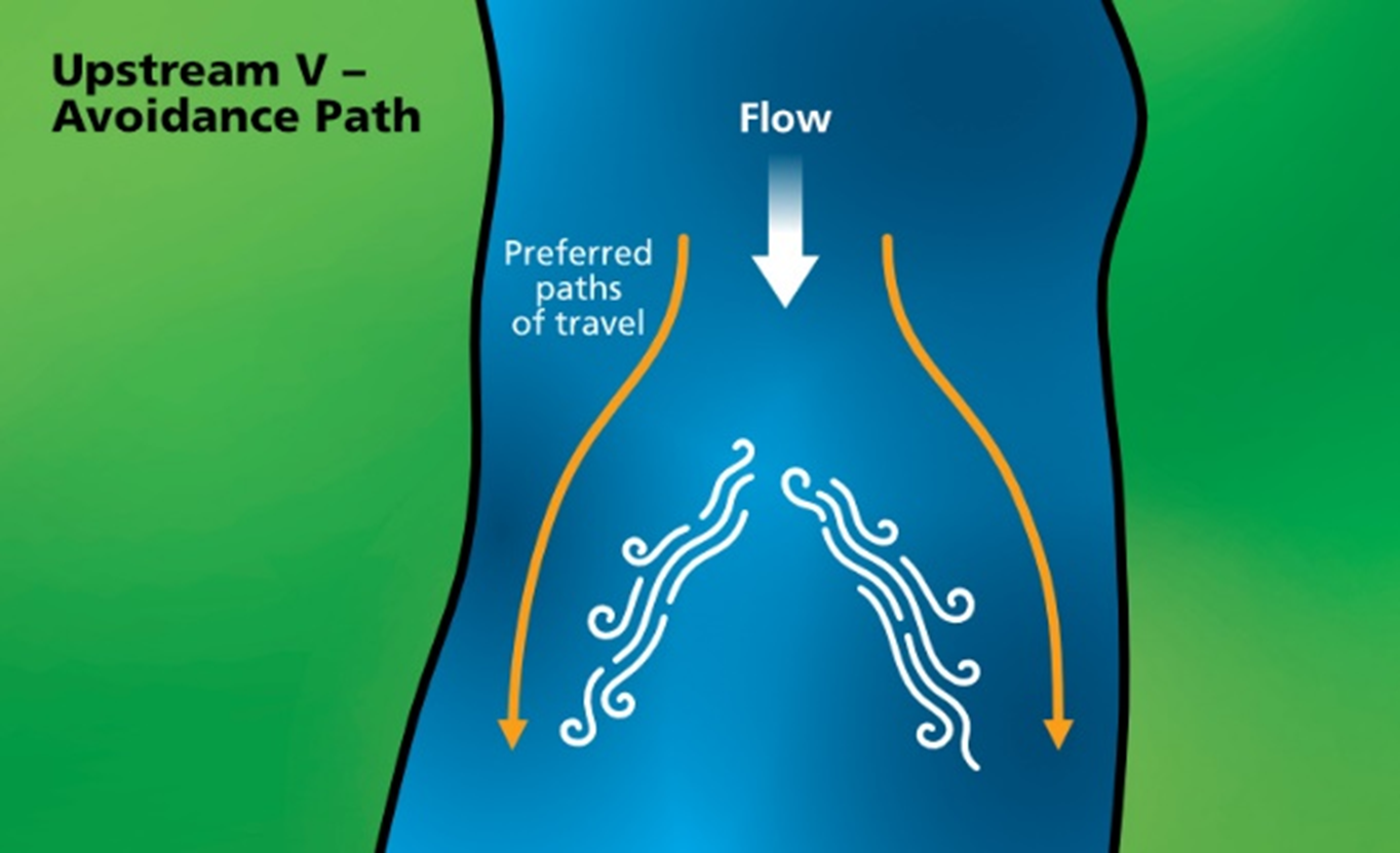
Figure 28: Preferred Paths of Travel – Downstream V
Overhanging branches
Overhanging branches have been known to break or collapse and become hazards in the water for swimmers. Large hanging branches are often used as a point of entry for jumping into the water but this is not recommended.
Strainers
Strainers are any fixed, or solid, objects in the water course that allows only water to pass over, under, around or through it. The most common strainers are fallen trees, rock groins, farm fencing and even traffic guard rails.
A swimmer may be held against a strainer resulting in injury, fatal or non-fatal drowning.
Figure 29: Strainer
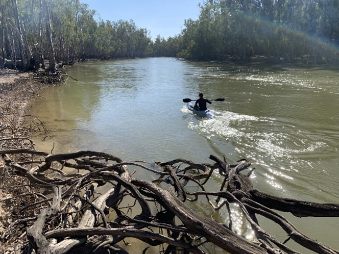
Submerged object
Submerged objects include any matter, natural or man-made that is underwater and may or may not be visually identified from the surface. Due to the nature of many inland waterways, submerged objects may not always remain stationary.
Swimming holes clear of submerged objects may rapidly change due to transitory submerged objects. This is important to remember in inland waterways, as many are surrounded by trees and vegetation which can be deposited into the water.
Submerged objects increase the risk of entrapment and/or a dangerous collision. The collision could occur between the submerged object and a watercraft, a water skier, a swimmer or someone who is entering the water.
Figure 30: Submerged obstacles

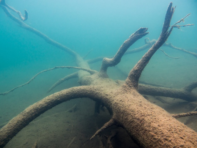
Snags
A snag is a submerged object under the surface (typically a fallen or submerged tree) which has the potential to ‘snag’ or catch swimmers or vessels as they pass over or through it. Snags are particularly hard to see under the surface and present a very real risk to swimmers and other water users.
Figure 31: Snag
Unknown horizons
When a river or canal drops away downstream, out of your vision, it is known as an unknown horizon. If on land, make every attempt to find out what is downstream, prior to any rescue attempt. If in the water, get out as quickly as possible. Horizons are evidence of a radical elevation change and can indicate dangerous rapids; a low head dam; or even a waterfall.
Figure 32: Unknown horizon
